Monthly Archives: April 2015

Wood Bison free in Alaska

From The Outdoor News Daily

The United States has a population of wild wood bison for the first time in more than 100 years.

On Friday, April 3, 100 wood bison which had been kept in temporary pens near Shageluk, Alaska, for just over a week were lead by Alaska Department of Fish and Game Biologist Tom Seaton across the Innoko River to freedom.

Bison Biologist Seaton opened the gates to the temporary pens and called the bison to follow his snowmobile across the Innoko River to sedge and grass meadows in the Lower Innoko/Yukon Rivers area which will become their new home. Bison galloped behind the snowmobile all the way across the river to the sedge meadow, a distance of nearly a mile.

The bison had been conditioned to follow a snowmobile distributing food pellets at the Alaska Wildlife Conservation Center (AWCC) where they have been cared for over the past decade.

Each of the 100 wood bison is wearing a radio collar. The herd will be intensively monitored over the next two years to learn where it roams and what their effects on the habitat will be.

The animals ranging in size from about 200 lbs to more than 1300 lbs, were placed in special shipping containers at AWCC March 22-24, trucked from Portage to Anchorage International Airport, and flown about 340 miles west to the village of Shageluk. The area was chosen for the wood bison restoration program because it provides excellent habitat and has strong public support.

Though lesser known than plains bison, wood bison flourished for thousands of years in Alaska and Canada, but disappeared from Alaska in the 1800s-early 1900s. Since 2003, the small herd has been growing at AWCC in Portage waiting for this reintroduction. ADF&G is planning to barge some adult bulls from AWCC out to the same area later this summer.

“The animals acclimated to Southwest Alaska very quickly and calmed down from the stress of travel within a week,” said Division of Wildlife Conservation Regional Supervisor David James. “The dream of wild wood bison that has been growing for the last two decades is now a reality.”

ADF&G staff followed protocols developed in Canada for a “soft release” of wood bison. “Rather than release them when they arrived in Shageluk, we held them until the stress of transportation subsided and then we lured them with a trail of food to sedge meadows a few miles away,” Seaton explained. “There is a lot of habitat in the Innoko region, and it is very exciting to think about what kind of resource this bison herd could be in a few decades.”

“We needed to get the cows out to the meadows before calving, which will happen in May, because calving should anchor them to their habitat,” Seaton added. About half of the adult cows are pregnant.

A small herd of wood bison remains at AWCC, where people can see and learn about these majestic animals.

“We’ve enjoyed caring for the herd, but it’s good to know they’re now free. We’re pleased to have played a role in bringing back a species from extinction,” said AWCC Executive Director Mike Miller.

Wood bison inhabited Alaska and northwestern Canada for thousands of years. Their numbers declined in the 1800s and they were declared extinct but a small herd was discovered in Canada in 1957. From that herd, conservation efforts have resulted in about 5,000 disease-free wood bison in seven wild herds in Canada.

Skeletal remains of wood bison and oral histories from some Alaska Natives in the eastern Interior show that wood bison disappeared from the state within the past 200 years, likely from a combination of habitat change and unregulated hunting. Wood bison were last sighted in Eastern Alaska in the 1920s.

Wood bison are grazers, which has been an empty niche in the boreal forest ecosystem in Alaska since bison disappeared. Wood bison are a slightly larger subspecies than the plains bison which roam the Continental 48 plains states, and are larger and more adapted to northern areas.

The Alaskan herd of wood bison has been maintained and grown under the supervision of the Alaska Wildlife Conservation Center staff since 2003.

Video footage of the river crossing to freedom is available at: https://www.hightail.com/download/UlRRNHA0QTY0b0NjZDhUQw.

Video interviews of Mike Miller, Executive Director of AWCC (tall man on left) and David James, ADF&G Regional Supervisor of Division of Wildlife Conservation (wearing blue hat) are available at: https://www.hightail.com/download/UlRRNHA0QTZEa1UwTWRVag.

For more information on bison in Alaska, visit: http://www.adfg.alaska.gov/index.cfm?adfg=woodbison.main.

The Alaska Wildlife Conservation Center is a 501 (c) (3) corporation dedicated to conservation, education, and quality animal care of Alaska’s wildlife. For more information about the center, visit: http://www.alaskawildlife.org/.

Quiz: Will these Monarch look-alikes fool you?

By Dani Tinker

from Wildlife Promise

Each spring I search desperately in butterfly gardens, hoping to catch a glimpse of a monarch butterfly. I’ll admit, there are a few butterfly species that trick me. The viceroy and queen butterflies are easy to confuse with monarchs. This guide and quiz will hopefully help you (and me) improve identification skills so that these look-alikes don’t fool us anymore. First, learn how to distinguish monarchs from their look-alikes, then put your skills to the test!

Go to http://blog.nwf.org/2015/03/quiz-will-these-monarch-look-alikes-fool-you/?s_email_id=20150407_MEM_ENG_MonarchQuiz_MEM_ACT|MTMemAct to take the quiz. Good luck.

Wasting disease spreads through more western Kansas deer

By Michael Pearce

The Wichita Eagle

Chronic wasting disease, an illness that’s 100 percent fatal in deer and elk, has spread to six more counties in southwest Kansas, authorities say.

To date, the disease has never been passed to humans or livestock, though it is related to mad cow disease and some other illnesses that can be fatal to both.

Shane Hesting, wildlife disease coordinator with the Kansas Department of Wildlife, Parks and Tourism, said of about 600 deer tested, nine carried the disease. Most were shot by hunters during deer seasons.

Counties where new cases of the disease have been found are Gray, Hodgeman, Kearny, Pawnee, Meade and Scott, with one diseased deer each. Decatur, Norton and Rawlins counties in northwest Kansas each had one deer test positive from last fall’s samples. All three counties have had multiple deer test positive for chronic wasting disease in past years.

Mule Deer by http://jenniferajarrett.blogspot.com/2012/03/deer.html

Mule Deer by http://jenniferajarrett.blogspot.com/2012/03/deer.html

Hesting said hunters who killed the animals are being notified of the results and, as a precaution, are being urged not to eat the venison. Areas where the disease has been found now stretch almost through western Kansas’ borders with Nebraska and Oklahoma. Biologists in Oklahoma have been notified the disease was found about 30 miles north of the state line.

Hesting said the six southwest Kansas deer that tested positive came from a test sample of 213 deer.

“It’s a small sample size, so the prevalence is probably higher than we expected in that part of the state,” said Hesting, who added that none of the 338 deer recently checked from south-central Kansas tested positive for chronic wasting disease.

He said the state focused its testing last fall on southwest and south-central Kansas. The three deer from northwest Kansas were tested because the hunters who killed them suspected the animals were ill because of actions or appearance.

Chronic wasting disease, a contagious neurological disease, was first discovered along the Wyoming-Colorado state line in the 1960s, affecting deer and elk. The disease spread slowly on its own but appears to have had some help as infected animals from game farms in that region were shipped across the country.

Chronic wasting disease has now shown up as far away as New York, southern New Mexico and parts of Saskatchewan in Canada.

It’s believed the disease is passed from animal to animal through things like saliva and feces, though it’s been known to contaminate an area for years in the soil. It is mostly contained in the central nervous system and bones of infected deer.

Some states no longer allow hunters to bring the complete skulls and bones of deer and elk they’ve shot from states with chronic wasting disease, like Kansas, into their home states. Hunters in many states are now advised to avoid contact with the brains and glands and to avoid cutting or breaking bones when they’re cleaning deer, elk or moose they’ve killed.

As the disease gradually spread into the Dakotas and Nebraska, Wildlife and Parks began testing deer in northwest Kansas for chronic wasting disease in 1996. The state’s first positive result in a wild deer occurred in 2005 in Cheyenne County, in extreme northwest Kansas. A captive elk transplanted from Colorado tested positive for the disease in Harper County in 2001.

Since 2005, 73 deer have tested positive in Kansas. Hesting said about 24,800 have been tested through the years.

Hesting said two of the bucks who tested positive were mule deer, of which only 51 were tested last fall. The rest were whitetails. All were bucks at least 3 1/2 years old when they were shot. All seven of the southwest Kansas bucks appeared healthy to the hunters and the technician who took the sample tissue or glands.

Lloyd Fox, Wildlife and Parks big game program coordinator, said initially most animals found with the disease in northwest Kansas appeared healthy. More and more are being found showing weakness, poor physical conditions or wandering aimlessly in that region because of the disease.

So far the disease hasn’t had much of an impact on the deer population in Kansas. Fox said that could change.

“The first few years, we see little impact, but most of us think it will, in decades, have to have a population effect as the environment becomes more contaminated,” he said. “When that happens, populations won’t jump back quickly from this. It’s a terrible disease.”

5 expert spring scouting tips from Dan Infalt

By Mark Kenyon

Wired To Hunt

We’re finally getting some warm weather up here in Michigan and the months-long blanket of snow is quickly disappearing. For us whitetail addicts, this melting of the snow means it’s time to get serious about spring scouting.

Last spring, we interviewed Dan Infalt on The Wired To Hunt Podcast about this very topic, and that episode has become one of our most listened to and applauded episodes of all time. Folks who listened to it, loved it. Why? Because Dan Infalt is a high-pressure/public land DIY big buck killing legend and his tactics can work for the average guy/gal, no matter where you hunt. That said, today I’ve pulled out five of the most important insights Dan shared in this podcast episode to help you get your spring scouting started off on the right foot. And if you want more information, I’d highly recommend you check out the full podcast episode here.

  1. Start with maps: Use aerial and topographic maps, either online or physical maps from someone like Hunterra, to identify likely locations on your property for high deer activity – like bedding areas, funnels and feeding locations. Then, once you head out to scout on the ground, you can spend your time most efficiently checking those areas first.
  2. Get out just after snow melt: When the snow melts, a whole new world of deer sign is uncovered. Scrapes, deer trails, and beds from the past fall can all be seen again in great detail, after being preserved and covered by the blanket of snow. Now’s the time to get out and take note of this sign before it’s covered up again by new spring growth.
  3. Identify bedding areas: The most important sign to identify, according to Infalt, are beds. Use the maps we mentioned earlier to identify likely bedding areas and then once you’re in the field you can double check your hunch. On your maps look for ridge-lines and points, islands or fingers of high ground in marshy spots, and areas of thick cover. When you get on the ground, search these areas for oval impressions on the ground that indicate a deer bed. If you see a number of beds together in a small area, this is likely doe bedding. If instead you find an individual large bed, placed in an ideal location, this is most likely a buck. Infalt believes that understanding buck beds is especially important if you hunt heavily pressured or public land, as mature bucks in those areas won’t travel far from their beds during daylight.
  4. Get to know buck beds: Speaking of beds, take special care to learn the details about individual buck beds. As mentioned above, a single large bed is a good indicator that this is a buck bed, but other characteristics of buck beds include rubs in or near the bed and some kind of back-cover like a downed tree or boulder. As Dan Infalt says, bucks will bed in a specific place for a specific reason – and you need to keep that in mind when you look for beds. A buck will typically bed in a certain place because it offers advantages that allow him to use his senses of sight, smell and sound to protect himself from danger. For example, an ideal buck bed location in hill country might be off the end of a point where he can see down into the valley below and smell anything coming from behind with a wind blowing over his head. When you find a buck bed, Infalt recommends you get right down in that bed and think through what that buck could see, hear and smell, and how that buck is likely coming in and out of the bed.
  5. Plan your set-up: Infalt believes that a big mistake a lot of hunters make is to identify buck bedding areas and then leave them without making a plan. Instead, once you identify a bedding area, identify where you can set-up just out of sight/sound/smell of a buck bedded there and then go find a tree. Map out how you could access a stand there and what wind directions you would need. If possible, get your stand hung, but if you’re not going to be able to hang a stand before the season, try and prep the tree as best as possible. Another thing to keep in mind is something Dan refers to as satellite bedding. The dominant buck in an area will often times claim the most ideal bedding location, but other bucks may come in wanting to bed there as well, and instead have to settle for a lesser location nearby. If you don’t locate these satellite locations prior to the hunting season, you could try to access your hunting area and spook these satellite bucks, which would in turn alert the dominant buck of your presence as well.

Want more scouting and high pressure/public land hunting advice from Dan Infalt? Check out the two very popular podcasts we’ve done with him, linked below:

The Wired To Hunt Podcast – Episode #3: Scouting and Hunting Heavily Pressured Whitetails w/Dan Infalt

The Wired To Hunt Podcast – Episode #27: Hunting the October Lull w/Dan Infalt

Digging deeper into Continuous CRP enrollments

From National Sustainable Agriculture Coalition

In March, NSAC teamed up with water quality, conservation, and grain and oilseed processor groups to encourage the USDA’s Farm Service Agency (FSA) to set aside at least a third of the Conservation Reserve Program (CRP) acres for Continuous Conservation Reserve Program (CCRP) including the Conservation Reserve Enhancement Program (CREP) and the State Acres for Wildlife (SAFE) program.

This post provides some background and statistical analysis of these special initiatives to help provide more context for the recommendations contained in the recommendations to FSA contained in that letter.

Background in Brief

While no general sign-up for CRP has been scheduled for 2015, farmers and landowners do have ongoing opportunities to enroll acres within the continuous enrollment programs. The CCRP is a voluntary, non-competitive enrollment program that helps protect millions of acres of America’s most environmentally sensitive farmland. The CCRP targets specific blocks of land that are most vulnerable to erosion, key for preventing polluted runoff, and prime acres for wildlife habitat.

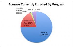
In the last five years, over 500,000 acres have been enrolled each year, and current contracts protect over six million acres reducing erosion, improving water quality, and restoring wildlife habitats.

As the name implies, enrollment in the CCRP happens on a continuous basis, and those determined eligible are automatically accepted into the program. This differs from the parent program, the Conservation Reserve Program (CRP), which features a competitive enrollment process with one general sign-up on an occasional basis.

Within the CRP, conservation practices eligible for CCRP include riparian, wetland, and wildlife habitat buffers, filter strips, wetland restoration, grass waterways, shelterbelts, windbreaks, living snow fences, contour grass strips, salt tolerant vegetation, and shallow water areas for wildlife.

In exchange for removing environmentally sensitive land from production, CCRP contracts include an annual rental payment, certain incentive payments, and up to 50 percent cost-share to install the practice.

Acreage-Currently-Enrolled-in-CRP-by-program


Regular CCRP Enrollments

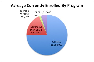
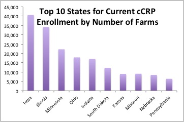
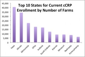
Currently, 4.52 million acres are currently enrolled in the mainstem of the CCRP program, with acres enrolled in all 50 states. Top users of the program include producers in Iowa, Minnesota, North and South Dakota, Illinois, Indiana, Nebraska, Kansas, and Missouri. Despite the fact that 30 percent of enrollments by number of farm occur in the top two states (IA and IL), looking at each state by total CCRP acres, enrollment is spread fairly evenly across cropland in across the country.

Top-10-States-for-Current-cCRP-Enrollment-by-Number-of-Farms


Top Practices

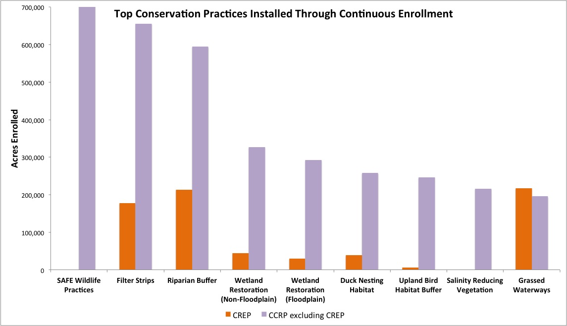
Within the CCRP (including CREP and SAFE — see below), the most popular enhancements are installing riparian buffers and filter strips, creating permanent wildlife habitat, and restoring wetlands.

Top-Practices-By-Continuous-Enrollment

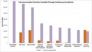
Farmers can protect the environment by placing small portions of their farms in permanent vegetation designed to control or intercept soil, nutrients, and pesticides and to slow wind and snow. Often referred to generically as conservation buffers, these targeted environmental practices can be in-field (e.g., contour grass strips), at the edge of fields (e.g., field borders), or along water bodies (e.g., riparian buffers). The best buffer strategies can remove 50 to 75 percent of nutrients and sediment from water bodies.

Buffers also provide food, cover, and shelter for some types of wildlife and also stabilize streams and reduce water temperature, benefiting fish and other aquatic species. And when used in conjunction with advanced farming practices like conservation tillage, cover cropping, crop rotation, and integrated pest management, buffer and related partial field vegetative practices help farmers become sustainable, environmentally and economically.

CCRP has been successful in targeting major erosion and water quality issues without sacrificing the productivity of entire fields. Because practices like Filter Strips make up smaller surface areas, these strategic enrollments have a disproportionately positive impact on stream health. In addition to controlling soil erosion, un-farmed strips of land give farmers access to parts of crop fields previously difficult to reach. Steep hillsides can also benefit from CCRP by installing contour buffers, grass waterways, and filter strips to help with drainage issues.

Ranchers benefit from using riparian buffers to protect from grazing along streams and ponds. Fencing cattle away from the buffer, installing alternative water sources, and planting trees the land adjacent to streams and ponds can help protect the land from erosion.

By enrolling their least productive soils, farmers can curb soil loss while attracting wildlife to their land and bring in additional economic benefits for the landowner. For areas that should never have been farmed to begin with, CCRP can be a useful tool to restore and land and return it back to its natural state.

Some conservation practices are more beneficial for particular regions, and as such are often concentrated in just a few states. For instance, Washington comprises 68 percent of the total acreage of contour grass strips in the US, while 90 percent of salinity reducing vegetation is in Montana and North Dakota and 64 percent of living snow fences are in Minnesota.

Conservation Reserve Enhancement Program

An offshoot of the CCRP is the Conservation Reserve Enhancement Program (CREP) under which a State agency and USDA together pay farmers to address targeted conservation issues identified by local, state, or tribal governments or non-governmental organizations. As a result of the added state funding, the average yearly rental payment per acre for CREP is $140, more than cCRP ($102), Farmable Wetland ($115), and General Signup ($51).

Top 10 states for CREP rental payments in dollars per acre

Iowa $263.20
Indiana $217.84
Illinois $210.75
Washington $194.37
Ohio $192.95
Kentucky $185.06
Maryland $170.22
New York $142.19
New Jersey $136.96
Idaho $132.77

CREP has been successful across the country to team up farmers and ranchers with state and federal efforts to address water quality and wildlife issues of concern at local, state, and regional levels.

▪ In Iowa, CREP is restoring wetlands to reduce nitrogen losses from the U.S. Corn Belt that cause hypoxia in the Gulf of Mexico. These sites have nearly 2,000 acres of strategically enrolled wetlands plus buffer that are designed to reduce nitrate run-off from over 52,000 acres of tile-drained cropland.

▪ In Missouri, two cities sharing a water supply have gotten 175 area farmers to voluntarily enroll over 6,700 acres in order to protect the high-quality drinking water in their manmade reservoir. To date, this CREP project has resulted in an average 16 percent reduction in pesticide application in the Smithville Lake Watershed.

▪ The New York City Watershed CREP project partners New York farmers with the Watershed Ag Program to maintain and improve the drinking water quality for New York City. By investing $35 million to implement best management practices on 85 percent of the 400 farms in the 500,000-acre watershed, the city was able to avoid building a costly water filtration plant.

Wildlife and Wetlands

There are a number of program initiatives within the CCRP including upland bird habitat buffers, State Acres For Wildlife (SAFE), and pollinator habitat. These targeted initiatives have enhanced wildlife habitat on thousands of acres across the country.

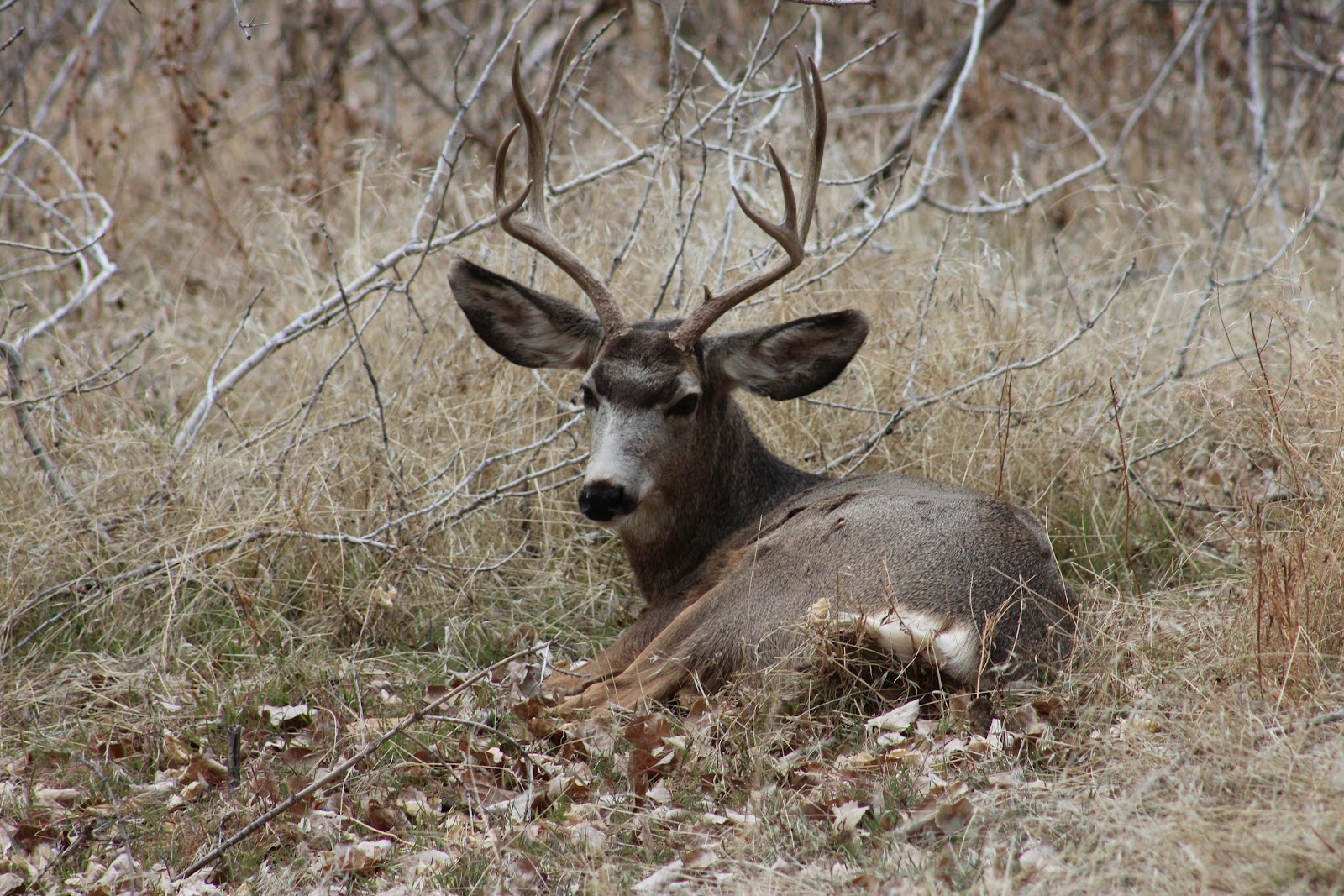
For instance, in South Dakota, these programs have improved the landscape across the state allowing for ducks, pheasants, sharp-tailed grouse, wildflowers, and deer to return in greater abundance.

Top 5 states for cumulative acres enrolled into CCRP program initiative Upland Bird

Habitat Buffers

IL 64,805
KS 40,457
MO 29,340
IA 25,860
OH 15,676

Top 5 states for cumulative acres enrolled into CCRP program initiative State Acres for

Wildlife (SAFE)

ID 106,070
ND 101,777
SD 98,480
TX 87,638
KS 79,216

Top 5 states for cumulative acres enrolled into CCRP program initiative

Pollinator Habitat

IA 8,504
IL 8,066
NE 1,653
CO 1,305
ID 630

Practices eligible for the SAFE program in order of popularity include installation of grass, trees, wetlands, buffers, and long leaf pine. Idaho, Texas, and South Dakota are top recipients of SAFE contracts, allocating 117,300 acres to the improve habitat for the Columbian Sharp-Tailed Grouse, 122,700 acres for Mixed Grass, and 81,500 acres to for pheasant habitat, respectively.

Specific Wildlife Practices

In November 2014, USDA increased the SAFE acreage allocation by 100,000 acres to 1,350,000 acres. As of January 15, there are nearly one million acres enrolled in the SAFE practices, leaving about 350,000 acres yet to be enrolled. These programs will be open until allocations are reached.

Acres allocated and enrolled into SAFE practices

Practice Acres Allocated Total Acres Enrolled % Enrolled Compared to Allocated
Flood-plain wetlands 531,400 292,644 55 %
Bottomland hardwood trees 250,000 112,883 45 %
Non-flood plain and playa wetlands 418,600 327,139 78 %
Upland bird habitat buffers 500,000 246,529 49 %
Longleaf pine plantings 250,000 137,307 55 %
Duck nesting habitat 300,000 258,186 86 %
State acres for wildlife enhancement (SAFE) 1,350,000 972,195 72 %
Highly erodible lands 750,000 244,086 33 %
Pollinator habitat 100,000 22,823 23 %


Conclusion

Since its inception, CCRP has been a vital tool for landowners to move a small, targeted portion of their land into various types of conservation buffers and habitat for extended periods of time in return for annual rental payments.

With over 6 million acres currently enrolled, USDA’s Farm Service Agency faces critical issues about how to manage the CCRP now that the 2014 Farm Bill has reduced the overall size of CRP in total. A key task will be ensuring sufficient acreage availability to maintain and grow the size of the CCRP over the coming five years to help address critical water quality and wildlife habitat issues.

Farmers and landowners face critical questions as well.

Those with land in the CCRP that is due to expire in the coming years face an important decision about whether to re-enroll for another decade.

Farmers and landowners with whole fields and farms in the regular CRP with contracts that are due to expire also face the question of whether to attempt to re-enroll or put the land back into production. For those choosing the latter course, an attractive option open to them is to keep buffer strips and targeted partial field practices in place through the CCRP while returning other portions of the farm to production. Choosing this option preserves important conservation values even as farms return to crop or livestock production.

Interested farmers and ranchers can learn more about the CCRP and how to apply in NSAC’s Grassroots Guide and can check out a variety of CCRP success stories on FSA’s website.

2013 Resolutions

2013 Resolutions:

No resolutions passed

2014 Resolutions

2014 Resolutions:

SUPPORT FOR THE INCREASED PRICE OF THE FEDERAL DUCK STAMP SUPPORT FOR THE INCREASED PRICE OF THE FEDERAL DUCK STAMP

CALL FOR PROTECTION OF PUBLIC LANDS AND WILDLIFE FROM FERAL CATS

PROMOTE CONTINUOUS CRP AS MEANS OF MAKING FARMING EASIER AND UPLAND BIRD FRIENDLY

OPPOSITION TO THE PRIVATIZATION OF WILDLIFE IN KANSAS

SUPPORT FOR INTEGRATED ROADSIDE VEGETATIVE MANAGEMENT ON COUNTY AND TOWNSHIP ROADS IN KANSAS

New report: Cropland expansion outpaces agricultural and biofuels policies

Land-use changes have caused the loss of over seven million acres of grasslands, wetlands and forests

From Environmental Research Letters

Recent land-use changes across the nation have caused the conversion of 7.34 million acres of grasslands, wetlands and forests to cropland, while 4.36 million acres of cropland were taken out of production according to a new report by the University of Wisconsin-Madison. Cropland Expansion Outpaces Agricultural and Biofuel Policies in the United States1 details the extent and location of land-use changes during the build-out of the corn ethanol industry.

The first crop and spatially-explicit nationwide assessment of its kind, the report uses remote sensing and other data to assess nationwide land-use changes between 2008 and 2012 and discusses the policy implications of such changes. The new, peer-reviewed study was published today in the journal Environmental Research Letters and addresses debate on whether the recent boom in demand for common biofuel crops and other agricultural policies have led to the carbon-emitting conversion of natural areas.

“We realized there was remarkably limited information about how croplands have expanded across the United States in recent years,” said Tyler Lark, lead author and PhD student at the University of Wisconsin-Madison. “Our results are surprising because they show large-scale conversion of new landscapes, which most people didn’t expect.”

The report finds that 5.7 million acres of grasslands, including native prairie, planted pasture, CRP and more, were the largest source of converted cropland, with 77 percent of new annual cropland coming from these perennial grass covers. These lost grasslands are now emitting significant quantities of carbon and no longer providing critical wildlife habitat. Grasslands are one of the fastest declining ecosystems in North America, with less than 10 percent of native grasslands left on the landscape. Of biggest concern, the report finds that an area of undisturbed prairie and range the size of the state of Delaware was converted to cropland.  Once grasslands are plowed, the full diversity of the ecosystem can never again be restored.  This loss is especially troubling as wildlife species that depend on this ecosystem, from the Monarch Butterfly to grassland nesting bird species, are in steep decline.

Forests were also a source for new cropland, causing the loss of about 200,000 acres of forests nationwide. While cropland expansion has taken place nationally, North and South Dakota have experienced the highest concentrations of total conversion to cropland, followed by Southern Iowa and Northern Missouri, and Western parts of Kansas, Oklahoma and Texas. The top states for loss of virgin sod were Texas (105,000 acres), Montana (93,000 acres), Kansas (83,000 acres) North Dakota (81,000 acres), and South Dakota (81,000 acres).

The authors found that conversion to corn and soy alone may have emitted as much carbon dioxide into the atmosphere as 34 coal-fired power plants operating for one year or 28 million more cars on the road.

“The study provides much needed information on the environmental impacts the expansion of cropland is causing.” said Julie Sibbing, Senior Director of Agriculture and Forestry programs at the National Wildlife Federation. “It’s also concerning that most of the land converted to cropland was not likely well suited for agriculture, which could lead to  increased erosion, flooding and drought, while millions of acres of cropland were abandoned, many of which should never have been brought into crop production in the first place. Our federal biofuels and agricultural policies are obviously broken and it is costing the taxpayers billions.”

Since the passage of the Renewable Fuel Standard 2 (RFS2) in 2007, environmental impacts of corn ethanol production have been hotly debated. The RFS2 mandated the greatly expanded use of biofuels as part of the nation’s fuel supply, and was designed to reduce greenhouse gas emissions from liquid transportation fuels. The regulation contains protections against the conversion of forests, wetlands and prairies for feedstock production, but has not been enforced to their full potential. The results of the study may guide policymakers as Congress debates whether to reform or repeal parts of the RFS2.

Other policy implications may also be involved with the results of the study. The Sodsaver provision of the 2014 Farm Bill currently reduces federal subsidies to farmers who grow on previously-uncultivated land, yet the provision only applies in six Northern Plain states. However, results from the study show that roughly two-thirds of the previously-uncultivated lands converted to crop production have been in states not covered by the Sodsaver provision.

“In order to protect remaining native ecosystems and critical wildlife habitat, our findings suggest a nationwide Sodsaver is needed,” said Lark.

Read NWF’s summary report at www.nwf.org/Farms-and-Forests or the original study at http://iopscience.iop.org/1748-9326/10/4/044003.

1 Lark et al 2015 Environ. Res. Lett. 10 044003

NRCS to provide $332 million to protect and restore agricultural working lands, grasslands and wetlands


The U.S. Department of Agriculture’s (USDA) Natural Resources Conservation Service (NRCS) is making available $332 million in financial and technical assistance through the  Agricultural Conservation Easement Program (ACEP). ACEP applications may be submitted at any time to NRCS; however, applications for the current funding cycle must be submitted on or before May 15, 2015.

ACEP easements help ensure productive farm and ranch lands remain in agriculture and protect the critical wetlands and grasslands, home to diverse wildlife and plant species. The 2014 Farm Bill consolidated three previous conservation easement programs into ACEP to make it easier for diverse agricultural landowners to fully benefit from conservation initiatives. In 2014, NRCS used $328 million in ACEP funding to enroll an estimated 145,000 acres of farmland, grassland, and wetlands through 485 new easements.

In Kansas, there are an estimated 4,800 acres of grasslands and wetlands enrolled through the new easements, according to NRCS State Conservationist, Eric B. Banks.

ACEP’s agricultural land easements not only protect the long-term viability of the nation’s food supply by preventing conversion of productive working lands to non-agricultural uses, but they also support environmental quality, historic preservation, wildlife habitat, and protection of open space. American Indian tribes, state and local governments, and non-governmental organizations that have farmland or grassland protection programs are eligible to partner with NRCS to purchase conservation easements nationwide.

A key change under the new agricultural land easement component is the new “grasslands of special environmental significance” that will protect high-quality grasslands that are under threat of conversion to cropping, urban development, and other non-grazing uses.

Wetland reserve easements allow landowners to successfully enhance and protect habitat for wildlife on their lands, reduce impacts from flooding, recharge groundwater, and provide outdoor recreational and educational opportunities. NRCS provides technical and financial assistance directly to private and tribal landowners to restore, protect, and enhance wetlands through the purchase of these easements. Eligible landowners can choose to enroll in a permanent or 30-year easement; tribal landowners also have the option of enrolling in 30-year contracts.

To learn about ACEP and other technical and financial assistance available through NRCS conservation programs, visit www.nrcs.usda.gov/GetStarted or your local USDA Service Center. USDA is an equal opportunity provider and employer.