State Issues

Conservation easements conserve Flint Hills vistas, wildlife

The Nature Conservancy of Kansas (TNC) has protected 3,285 acres of Flint Hills tallgrass native prairie with a conservation easement in Chase and Lyon counties. The landowners, Bill and Maggie Haw of Shawnee Mission, are firm believers in conservation easements, having previously donated to TNC easements on other land they own and manage in the Flint Hills. This recent easement brings their total land protection contribution to more than 17,000 acres, including 16 scenic miles of highway frontage along the Kansas Turnpike (I-35) and the Flint Hills National Scenic Byway (K-177).

Tallgrass prairie is the most altered major habitat type in North America in terms of acres lost. Yet, in Kansas, a significant swath of tallgrass prairie – the Flint Hills –remains intact. TNC views conservation easements as a golden opportunity to help landowners conserve this intact and fully functioning tallgrass prairie ecosystem.

A conservation easement is a legally recorded agreement between the granting landowner and a land trust. The agreement permanently restricts uses of the property that would damage its conservation values. Conservation easements do not interfere with traditional uses of the land, such as grazing and prescribed fire, but it may restrict incompatible activities, including many types of development. Public access is generally not required by a conservation easement, and, like all other easement provisions, it must be agreed to by the landowner. An eased property may be sold, transferred or inherited, and the easement conditions transfer to each subsequent landowner.

“By placing these acres under the protection of a conservation easement, the property’s ranching legacy, as well as its economic and ecological integrity, will endure,” said Brian Obermeyer, director of the TNC’s Flint Hills Initiative.

“Maggie and I are committed to the idea of preserving not only the pristine views but also the wonderful cattle culture of this area where generations of same-family cowboy caretakers have learned to operate the best yearling grazing operations in the world,” said Bill Haw. “It is the perfect convergence of an important food-producing activity that maintains the ecosystem, which developed with bison grazing over thousands of years. The Nature Conservancy is the perfect partner to recognize and enforce those two compatible goals for many generations to come.”

The recent Haw easement takes TNC over the 100,000-acres-preserved mark in Kansas.

For more information about The Nature Conservancy and conservation easements, contact Shelby Stacy at [email protected] or (785) 233-4400.

WAFWA Kansas land acquisition protects Lesser Prairie-chicken habitat


The Western Association of Fish and Wildlife Agencies (WAFWA) has finalized the purchase of approximately 30,000 acres of high-quality lesser prairie-chicken habitat in southwest Kansas. The permanent protection and long-term conservation of lesser prairie-chicken habitat is an important goal of the Lesser Prairie-Chicken Range-wide Conservation Plan. Funding for this acquisition comes from the voluntary contributions of industry partners that are enrolled in the range-wide plan.

“The acquisition of Sunview Ranch is a significant positive development to conserve the lesser prairie-chicken,” said Alexa Sandoval, director of the New Mexico Department of Game and Fish and chairman of the Lesser Prairie-Chicken Initiative Council. “This transaction involved a willing seller of land that contains prime lesser prairie-chicken habitat and furthers our goal of providing a stronghold of at least 25,000 acres in each of the ecoregions where the lesser prairie-chicken is still found. We commend all of our partners for their continued commitment to conservation of the lesser prairie-chicken.”

            The range-wide plan is a collaborative effort of WAFWA and the state wildlife agencies of Kansas, Colorado, New Mexico, Oklahoma and Texas. It was developed to ensure conservation of the lesser prairie-chicken through voluntary cooperation by landowners and industry. The plan allows agriculture producers and industry to continue operations while reducing impacts to the bird and its grassland habitat.

            The Sunview Ranch (formerly Tate Ranch) is in the sand sagebrush ecoregion, which covers portions of Kansas, Colorado and Oklahoma and once contained the highest density of lesser prairie-chickens in the country. The dominant vegetation on rangelands in the region is sand sagebrush, which is a native shrub typically associated with deep sandy soils in dune landscapes. Livestock grazing is the primary land use on rangeland throughout the sand sagebrush region, and through grazing leases, it will continue to be used as a management tool on the Sunview Ranch.

            “This property is one of the largest remaining contiguous tracts of sand sagebrush prairie in the region,” said Jim Pitman, Conservation Delivery Director for WAFWA. “Conserving this property in perpetuity ensures that it will remain a working ranch and continue to provide habitat for the lesser prairie-chicken in the portion of its range where the population has declined the most.”

            For more information, contact Bill Van Pelt at (602) 717-5066 or [email protected], or visit www.wafwa.org.

Zebra Mussels found In Hillsdale Reservoir

The presence of invasive zebra mussels has been confirmed in Hillsdale Reservoir in Miami County. On Wednesday, June 15, an alert angler found an adult zebra mussel at the Wade Branch of the reservoir and took it to the Hillsdale State Park Office. Kansas Department of Wildlife, Parks and Tourism (KDWPT) aquatic nuisance species staff subsequently found more zebra mussels on rocks and trees in the same area. The population appears to be low density at this time, however, there is no known method to completely rid a lake of zebra mussels.

“Since zebra mussel larvae, or veligers, are microscopic and undetectable to the naked eye, all users of Kansas lakes need to be aware that transfer of water between lakes can lead to further infestations,” said Jeff Koch, KDWPT Aquatic Research Biologist.

Prevention is the best way to avoid spreading Aquatic Nuisance Species (ANS). They often travel by “hitchhiking” with unsuspecting lake-goers. “We encourage anyone who recreates on Kansas lakes to clean, drain, and dry their boats and equipment before using another lake. Additionally, don’t transfer lake water or live fish into another body of water, as this is a main transport vector of all aquatic nuisance species,” Koch added.

Hillsdale Reservoir and Bull Creek from the reservoir south to the Marais des Cygnes River will be added to the list of ANS-designated waters in Kansas, and notices will be posted at various locations around the reservoir. Live fish may not be transported from ANS-designated waters.

The sharp-shelled zebra mussels attach to solid objects, so lake-goers should be careful when handling mussel-encrusted objects and when grabbing an underwater object when they can’t see what their hands may be grasping. Visitors should protect their feet when walking on underwater or shoreline rocks.

Zebra mussels are just one of the non-native aquatic species that threaten our waters and native wildlife. After using any body of water, people must remember to follow regulations and precautions that will prevent their spread:

▪ Clean, drain and dry boats and equipment between uses

▪ Use wild-caught bait only in the lake or pool where it was caught

▪ Do not move live fish from waters infested with zebra mussels or other aquatic nuisance species

▪ Drain livewells and bilges and remove drain plugs from all vessels prior to transport from any Kansas water on a public highway

For more information, to report the presence of a possible ANS, or see a list of ANS-designated waters, visit ProtectKSWaters.org.

For information about Hillsdale Reservoir, visit www.ksoutdoors.com.

KAWS celebrates 20 years of wetland conservation in Kansas

Last month, Kansas Alliance for Wetlands and Streams (KAWS) celebrated its 20th anniversary. Since its inception in 1996, KAWS has been collaborating with local communities, conservation organizations, wildlife agencies and local governments to promote conservation of the streams, riparian areas, playas and prairies of Kansas. They have brought together a broad range of partners—including Ducks Unlimited, Kansas Department of Wildlife, Parks and Tourism, Kansas Cooperative Fish and Wildlife Unit, Kansas Water Office, The Nature Conservancy, University of Kansas, and Playa Lakes Joint Venture—to work on water and wildlife issues in Kansas.

“It is so gratifying to help via a capacity grant and then watch as groups like KAWS flourish into go-to partners on the landscape,” says PLJV Coordinator Mike Carter. “We wish KAWS another 20 years of successful wetland conservation!”

In 2002, KAWS received a six-year capacity grant from PLJV to help increase their ongoing ability to develop and deliver habitat conservation. The PLJV Capacity Grant Program is designed to remove roadblocks to habitat conservation— and can help new organizations get on their feet and move beyond current capabilities—rather than directly support any particular habitat project. During the grant period, KAWS influenced the conservation or restoration of about 5,000 wetland acres. A second six-year grant, which started in 2008, provided funding for a wetland coordinator who focused on playa conservation. Over the lifespan of the second agreement, nearly 2,500 acres of wetlands and buffer were restored or protected, and the number of acres have continued to increase in the years since the grant ended.

KAWS continues to build its playa conservation program under the leadership of Joe Kramer, who took on the wetland coordinator position in January 2015. Beginning next year, the organization will host an annual Playa Symposium, featuring tours of playas and demonstrations of innovative projects that integrate playas and native buffers into profitable yet ecological systems.

“Our priority is to set the stage with knowledge, innovation, entrepreneurship and local leadership,” says KAWS Executive Director Jeff Neel. “By working with our partners and local landowners, we hope to achieve ecological connectivity of playas that benefit migratory birds, wildlife ecology and recharge potential for the Ogallala while supporting the bottom lines and economies of farms and ranches.”

Two $1 million grants support wetland conservation in Colorado and Kansas


Earlier this year, Ducks Unlimited was awarded two $1 million grants for wetland habitat conservation and restoration in Colorado and Kansas from the North American Wetland Conservation Act (NAWCA) standard grant program. Both grants will help Ducks Unlimited and its partners continue providing important wetland and grassland habitat for migratory birds.


“Water, especially, is a resource that migratory bird managers must carefully safeguard,” says Matt Reddy, a regional biologist for Ducks Unlimited. “The work we are doing along the South Platte gives us an opportunity to educate the public about the value of wetland conservation and share the joy many of us feel witnessing the spectacle of waterfowl migration.”


According to Reddy, the ability of the South Platte Basin to support abundant populations of waterfowl continues to be challenged by the increasing pressure on the river to supply municipal, industrial, agricultural and recreational resources. The Platte River Wetlands Partnership, now in its fourth phase, is currently working to improve habitats on publicly-accessible tracts along the river in Colorado, with the majority of the project focused on public properties or on areas that are adjacent to already conserved properties. The project is aimed at improving the quantity, quality and availability of preferred habitats for the ducks, geese and other waterbirds that rely upon the Platte River as a stopover point on their migration to and from breeding grounds to the north.


The Kansas Prairie Wetlands project includes a number of important wetland complexes that have been identified as areas of significance to North American waterfowl and other wetland birds. In particular, Quivira National Wildlife Refuge and Cheyenne Bottoms have been identified as areas of regional and hemispheric importance to shorebirds by the Western Shorebird Hemispheric Reserve Network (WSHRN). These habitats provide critical links between Prairie Pothole breeding areas, the Rainwater Basins in Nebraska, and wintering habitats along the Gulf Coast and in the High Plains playa region of Texas; and they support hundreds of thousands of shorebirds during migration within the Central Flyway.

Error causes some hunters to receive duplicate deer permits


Several thousand nonresident hunters who successfully drew Kansas deer permits from the April drawing received a surprise mailing in early June. Due to a printing error at a fulfillment service contracted to print and mail permits to the 21,225 successful applicants, nearly 3,260 hunters received duplicate mailings. 


A successful applicant should have received only one mailing with one set of permits, which included an either-sex permit and carcass tag and a whitetail antlerless-only permit and carcass tag. Kansas Department of Wildlife, Parks and Tourism (KDWPT) officials want to remind hunters that the law only allows them to have one permit that allows the harvest of an antlered deer, so only one set of the permits they received is valid. Duplicate permits may not be used or transferred to another hunter.


Hunters who received duplicate permits and carcass tags are asked to return duplicate sets to the KDWPT Licensing Section, 512 SE 25th Ave., Pratt, KS 67124. Department staff are working with the contractor to identify issues that led to the error and to ensure that all successful applicants received the correct permit, and that those who received duplicate permits are notified.


All applicants who were unsuccessful in the drawing should have received their refunds, and all successful applicants should have received their set of permits by now. Hunters can see their status in the draw at www.ksoutdoors.com and clicking on the “Nonresident Deer Permit Draw Results” button on the left-hand edge of the homepage. If you have questions, please contact Mike Miller at 620-672-0765 or Ron Kaufman at 785-296-2870.

New Habitat First program offers wildlife habitat assistance

Habitat First is a new program developed by the Kansas Department of Wildlife, Parks and Tourism’s (KDWPT) Wildlife Division for private landowners interested in developing or enhancing wildlife habitat on their land. Under the program, district wildlife biologists will deliver the following services to interested landowners:

-Technical assistance: planning, land management support, and habitat development tools

-Financial assistance: cost-share and sign-on incentives for habitat improvements

-Equipment loans: native grass drills, tree planters, fabric machines, prescribed burn equipment, and root plows

-USDA programs: assistance with Environmental Quality Incentive Program applications benefiting wildlife, Conservation Reserve Program enrollment, and management

Standardized practices and rates make the program easy to explain and understand. Habitat management plans can be tailored to the property and to landowner preferences.

Visit www.ksoutdoors.com/Private-Lands, call 620-672-5911 or contact the nearest KDWPT office to learn more.

Steele House nominated to National Register

At its meeting on Saturday, April 30, the Kansas Historic Sites Board of Review voted to nominate the Steele House at Lake Scott State Park to the National Register of Historic Places. This action sends the nomination to the National Park Service for their consideration and final action. It also adds the home to the state’s Register of Kansas Historic Places.

The Steele House was built ca. 1894 by Herbert and Eliza Steele on the west bank of Ladder Creek in what later became Lake Scott State Park. They were among the earliest Euro-American settlers in the county. The seven-room, two-level limestone house was built into the side of a hill so the lower level is partly recessed into the hill. The nomination also includes a crude limestone spring house built by the Steeles over a still-active spring and a decorative pond and bench built with help from the Civilian Conservation Corps ca. 1934 after the Steeles had passed away.

Lake Scott State Park is located in Ladder Creek Canyon about 13 miles north of Scott City in Scott County. Before Euro-American settlement, the canyon was home to several Central Plains Native American groups, dating to proto historic and early historic times. El Cuartelejo, the remains of the northeastern-most pueblo in the U.S., are located a short distance north of the Steele House. The El Cuartelejo Archaeological District National Historic Landmark established in 1964 – a concentration of remnants from these cultural groups – surrounds the Steele House and was made possible by the Steeles’ willingness to have their land investigated by archeologists beginning in the late 1890s.

The Steeles were aware their picturesque property was an ideal setting for a park. In 1928, they sold 640 acres of their land to the Kansas Forestry, Fish and Game Commission – a forerunner of the Kansas Department of Wildlife, Parks and Tourism (KDWPT) with the stipulation they be allowed to live in their home until their passing. In May 1930, the Commission completed a dam across Ladder Creek and created the 100-acre Lake McBride which later was renamed to Lake Scott.

Herbert Steele passed away in September 1929, having never seen the lake and park he helped create. Eliza Steele died in July 1930, one month after the park opened. Today, the house is a museum operated by volunteers.

Lake Scott State Park is a featured location along the Western Vistas Historic Byway. The National Register nomination application can be found online at http://www.kshs.org/p/hsbr-meeting-april-30-2016/14633. More information about the park is located at http://ksoutdoors.com/State-Parks/Locations/Scott. Information about the Western Vistas Historic Byway is at http://www.westernvistashistoricbyway.com/

Biologists take tissue samples to evaluate bass stocking program

Fisheries biologists at the Meade Fish Hatchery have been fooling Mother Nature to get largemouth bass to spawn earlier than normal. By controlling water temperature and photo-period (day length), along with other biological factors, hatchery staff are able to create an environment where largemouth bass spawn up to two months earlier than they would in the wild. The fry produced have a huge advantage over naturally-spawned bass because they are large enough to feed on small fish through the spring and summer. By fall, these larger bass are more likely to survive their first winter in a Kansas lake.

So far, early-spawn bass have been stocked into select Kansas reservoirs where bass are popular with anglers but natural reproduction and normal stocking practices aren’t maintaining good bass populations. To evaluate the success of the early-spawn program, fisheries staff have conducted creel surveys to determine if catch rates have improved. In addition, DNA testing of adult bass caught in these lakes will tell biologists what percentage of the bass population is made up of early-spawn fish.

A unique quality of the early-spawn program is that genetic records kept on the brood fish allow each bass produced to be traced back to the hatchery. KDWPT biologists are working with bass tournament organizers to obtain samples from bass brought to tournament weigh-ins at select lakes. Recently, staff worked with the East Kansas Bassmasters club during a tournament on Hillsdale Reservoir where early-spawn bass have been stocked since 2012. Fingernail-sized clippings from the upper caudal fin were collected from fish at the weigh-in before the bass were released. The tissue samples will be tested to determine if they came from fish produced at the Meade Fish Hatchery.

In the past five years, more than 10 million largemouth bass have been produced and stocked through the early-spawn procedure. The evaluation efforts will help biologists determine the program’s effectiveness in bolstering bass populations, as well as what changes should be made to improve stocking success.

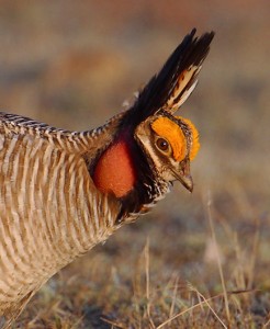
Lesser Prairie-chicken range-wide plan reports successful second year

ChickenCloseup-9594C

On March 31, 2016, the Western Association of Fish and Wildlife Agencies (WAFWA) submitted to the U.S. Fish and Wildlife Service (USFWS) its second annual report, detailing achievements of the Lesser Prairie-chicken Range-wide Conservation Plan (LPRCP). Highlights include the estimated 25 percent increase in the range-wide lesser prairie-chicken  population to just over 29,000 birds, the nearly $51 million in fees committed by industry partners to pay for mitigation actions, and the more than 67,000 acres of habitat landowners across the range have agreed to conserve.

The range-wide plan is a collaborative effort of WAFWA and the state wildlife agencies of Texas, New Mexico, Oklahoma, Kansas and Colorado. It was developed to ensure conservation of the lesser prairie-chicken with voluntary cooperation from landowners and industry. This plan allows agriculture producers and industry to continue operations while reducing impacts to the bird and its grassland habitat.

“Conservation of the lesser Prairie-chicken is a long-haul proposition,” said Alexa Sandoval, director of the New Mexico Department of Game and Fish and chairman of the Lesser Prairie-chicken Initiative (LCPI) Council. “We’re encouraged that after just two years of implementation, we have so many positive indicators that the range-wide plan is working. We commend all of our partners for their commitment to conservation of this iconic grassland species.”

The plan was endorsed by the USFWS, and as part of the conservation agreement, the states agreed to report progress annually. The findings for 2015 are summarized below.

Lesser Prairie-chicken Population Up

The 2015 range-wide aerial survey documented a 25 percent increase in the lesser prairie-chicken population to an estimated total of 29,162 birds. This increase is attributed to an abundance of rainfall in spring 2015, along with ongoing range-wide plan conservation initiatives. Aerial surveys for 2016 are underway and will run through mid-May. Results are anticipated in early July.

Land Conservation Efforts Increasing

Substantial progress was made on private land conservation across the lesser prairie-chicken’s range. Eight landowner contracts were finalized, encompassing 67,512 acres. Conservation measures are being implemented range-wide, including habitat restoration on 8,214 of 15,911 prescribed acres. And a total of $1,821,737 was paid to landowners managing their lands to generate credits for lesser prairie-chicken conservation. In addition, WAFWA acquired title to a 1,604-acre tract of native rangeland in west Texas, near the Yoakum Dunes Wildlife Management Area last June.

Technology Enhances Conservation Decision Making

Scientists are using the latest technology to designate where and how conservation actions should be implemented for the greatest benefit. The Southern Great Plains Crucial Habitat Assessment Tool enhances the existing Crucial Habitat Assessment Tool (CHAT) program administered by WAFWA. It identifies focal areas and connectivity zones where lesser prairie-chicken conservation actions will be emphasized. A project estimator tool unique to CHAT was designed to encourage companies to implement more effective pre-planning development efforts and it worked. These enhancements have resulted in 5,066 instances of access to CHAT, with an average of 145 users per week.

Cooperative Efforts Enhancing Conservation

Working with conservation partners, programs and cooperative efforts are expanding voluntary landowner incentives and practices to benefit the birds. For example, the Natural Resource Conservation Service has incorporated CHAT elements into the ranking criteria for projects being considered under the Lesser Prairie-chicken Initiative. Using CHAT, prescribed grazing practices were applied on 179,805 acres through the Lesser Prairie-chicken Initiative in 2015. These combined efforts have resulted in nearly 250,000 acres being conserved for the benefit of the lesser prairie-chicken.

Mitigation Efforts Positively Impact Development Decisions

One of the major components of the range-wide plan involves working with industry to avoid and minimize impacts of development activities. The WAFWA mitigation framework can be used by any entity. In 2015, there were several industries participating, including oil and gas, pipeline, electric, wind energy and telecommunications. During this past year, 177 companies enrolled in WAFWA conservation agreements. WAFWA collected $11,843,403 in fees in 2015, bringing the program total to $50,800,884, which will offset unavoidable impacts at off-site mitigation locations. In 2015, 409 project agreements were authorized, assessing development costs tied to the quality of habitat being impacted. After two years of implementation, a review of all the projects assessed shows that the mean cost was $11,936 per project, varying by ecoregion. WAFWA has documented that these mitigation costs are positively impacting development decisions and participants are actively selecting areas with low quality habitat.

Listening and Learning Informs All Conservation Decisions

Successful collaborative efforts require vigilance and commitment to considering all input. Through the Lesser Prairie-chicken  Advisory Committee, WAFWA has been receptive to input from all stakeholders, including industry, non-governmental organizations, state and federal agencies, landowners and the general public. The LPCI Council has developed an adaptive management framework incorporating monitoring and new information to make adjustments as needed, maximizing conservation benefits to the lesser prairie-chicken.

Full details are available in the WAFWA annual report at www.wafwa.org